Contents
- 1 In which Hemisphere India is located Eastern or Western?
- 2 An overview of India: Geographical location of India
- 3 List of countries according to their Size
- 4 How many Hemisphere are their in the Globe
- 5 Division of the Earth
- 6 What is the difference between Latitude and Longitude?
- 7 Longitude
- 8 Latitude
- 9
- 10 Conclusion
It might be hard to remember how many Hemispheres there are, but there’s a lot of information out there about which one India is in. But there’s one question that’s been on a lot of people’s minds “In which Hemisphere India is located” That’s what this blog is going to answer. It will also point out the important information about the different hemispheres and how many are there.
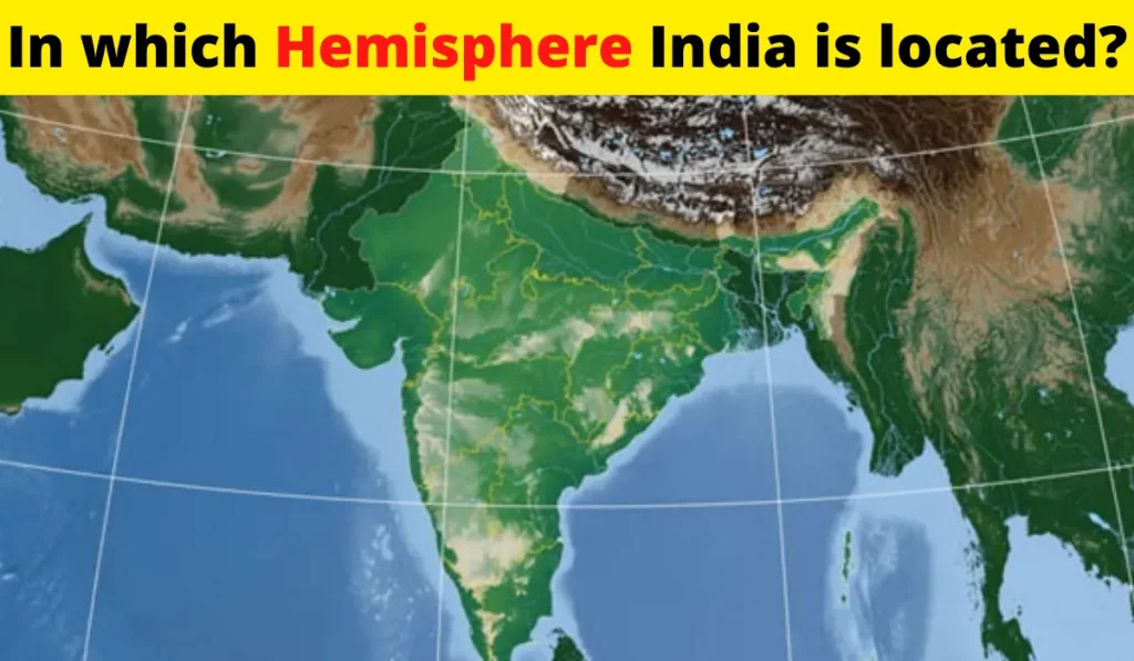
India is a vast country. India is located in Northern hemisphere. The main land extends between latitudes 8o4’N and 37o6’E and 97o25’E. The tropic of cancer (23o30’N) divides the country into half equal parts.
In which Hemisphere India is located Eastern or Western?
India is located latitudinally in Northern hemisphere but in longitudinally it is located in Eastern hemisphere. If you went into your backyard and started digging you would eventually go all the way through the world and end up at the other side the other side of the world from us is called the eastern hemisphere and there’s a lot to learn about that half of the world. The first continent we’re talking about today is Asia. A lot of people live in Asia in fact over half of the people in the world live there. There are a lot of different countries in Asia like China, India, Japan, Indonesia, Russia and more because of how big Asia is there’s a lot of stuff to see there including the highest place on earth Mount Everest and the lowest place on the land the Dead sea.
An overview of India: Geographical location of India
Talking about land mass of India it is 3.28 million km2. India has a total area of about 2.4% of a geographical area of the world. And also talking about size India is the seventh largest country among the world. India has a land boundary of 15,200km. The total length of the coast line of the mainland is 7,516.6km. India is bounded by the mountains in the northwest, north and north east. South of about 22onorth latitude, it begins to taper, and extends towards the Indian Ocean.
Dividing it into two seas, the Arabian sea on the west and the Bay of Bengal on its east and also latitudinal and longitudinal extent of the mainland is 30o. If time is compared between Gujrat to Arunachal Pradesh there is a major difference of two hours. Time along the standard Meridian of India(82o30’E) passing through Mirzapur (in Uttar Pradesh) is taken as the standard time for the whole country.
List of countries according to their Size
- Russia
- Canada
- U.S
- China
- Brazil
- Australia
- India
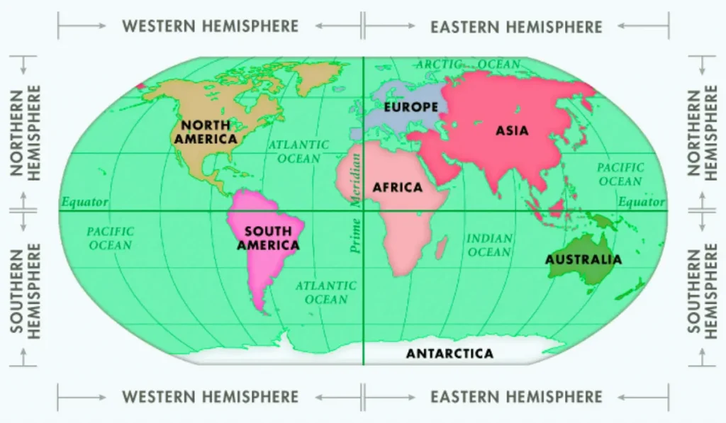
How many Hemisphere are their in the Globe
Their are four types of Hemisphere:
- Northern Hemisphere
- Southern Hemisphere
- Eastern Hemisphere
- Western Hemisphere
1.Northern Hemisphere
Northern hemisphere can be defined as the 1/2 of the earth that lies north of the equator.
- Countries– 160+ countries
- Population- 6.92 Billion
- Most populated country- China
- Area- 100,236,620 km2
- Largest country by area- Russia
- GDP (Nominal)- $91.95 trillion
- Most followed religion- Islam(1.65 Billion)
2. Southern Hemisphere
Southern hemisphere can be defined as the 1/2 of the earth that lies south of the equator.
- Countries– 45+ countries
- Population- 1.03 Billion
- Most populated country- Indonesia
- Area- 48,703,380 km2
- Largest country by area- Brazil
- GDP (Nominal)- $8.05 trillion
- Most followed religion- Christianity(850 Million)
3.Eastern Hemisphere
Eastern hemisphere can be defined as the 1/2 of the earth that lies east of the equator.
- Countries– 145+ countries
- Population- 6.68 Billion
- Most populated country- China
- Area- 96,211,000 km2
- Largest country by area- Russia
- GDP (Nominal)- $57.2 trillion
- Most followed religion- Islam(1.7 Billion)
4.Western Hemisphere
Western hemisphere can be defined as the 1/2 of the earth that lies west of the equator.
- Countries– 62+ countries
- Population- 1.27 Billion
- Most populated country- United States
- Area- 52,729,000 km2
- Largest country by area- Canada
- GDP (Nominal)- $42.8 trillion
- Most followed religion- Christianity(1.01 Billion)
Division of the Earth
The earth can be divided in many ways. But, we will talk about seven most important divisions on the planet:
- Equator
- Northern hemisphere
- Southern hemisphere
- Tropic of Capricorn
- Tropic of cancer
- North pole
- South pole
What is the difference between Latitude and Longitude?
The line of longitude and latitude are two sets of imaginary lines that envelope the earth. They are used to specify the geographical coordinates of a location on earth.
Longitude
- The lines of longitude run from the north pole to the south pole.
- Longitude lines are long lines holding the Rungs together.
- Values range from 0 to 180 degrees. Here, 0 represent prime meridian and 180 represent International Data Line.
- A geographic co-ordinates that specifies the east-west position of a point on the earth’s surface.
Latitude
- The lines of latitude run from the east to the west.
- Latitude lines are Rungs.
- Values range from 0 to 90 degrees. The values for latitude are Positive in the northern hemisphere and Negative in the Southern Hemisphere.
- A geographic co-ordinates that is particular for north-south position of a point on the earth’s surface.
Q1: What is the highest point in India?
Kangchenjunga is the highest point in India. Its lies b/w India and Nepal border.
Its comes under Himalayas mountain range. Its elevation from sea level is 8,586m.
It is also the 3rd highest mountain in the world.
Q2: Where is the lowest point in India?
Kuttanad is the lowest point in India. Its lies b/w disputed territory of India and Pakistan. Its location is Alappuzha district in the state of Kerala. Its altitude from sea level is -2.2m (-7.2ft).
Q3: Which is the last point of India?
Dhanushkodi Beach is the last point of India. Its lies b/w two meeting point of oceans that is Bay of Bengal and Indian Ocean. The last point of India is also famous because Ramsetu is situated in Dhanushkodi Beach.
Conclusion
India is a country in South Asia that is made up of two major land masses, the Indian Subcontinent and the Indian Ocean. India is located in the Eastern hemisphere and is also the seventh largest country in the world. India’s flag has three horizontal stripes of deep saffron (tan), white, and green with a red wheel in the center.
We hope you enjoyed our blog about where India is located. India is located in the southernmost part of the Indian subcontinent and the southeastern tip of Asia. It is bordered by Pakistan to the west, China to the east, Nepal and Bhutan to the north, and Myanmar to the southeast.
We hope you found this blog post informative. If you have any more questions, please contact us at EduKar.
Thank you for reading and we hope to hear from you soon!


? Explained")

")